 Most people believe the Tower of Babel was built somewhere in Iraq or even modern-day Syria. However, a recent article proposed that the Tower of Babel was built farther north in southeast Turkey.1 While their research needs verification, this conclusion may alleviate some of the criticism raised against my earlier proposed Ark landing site.2
In 2019, I suggested the Ark landed about 70 miles or so west of Mt. Ararat on Kagizman Ridge (Figure 1). This so-called paleo-ridge3 extends east-west for over 100 miles, with some sections above 10,000 feet in elevation. This uplift likely formed at about the highest water point of the Flood at the end of the Zuni Megasequence, placing its development about Day 150 of the Flood year. According to the biblical text, this was exactly when the Ark ran aground (Genesis 8:4). Figure 1 shows this ridge extends west from Mt. Ararat, further qualifying it as part of the “mountains of Ararat.”
The reason I discounted Mt. Ararat itself as the Ark’s landing site is because much of Mt. Ararat formed from more recent volcanism during the Ice Age, well after the Flood was over.2 Of course, it is still possible the Ark landed there and was subsequently buried as Mt. Ararat’s volcano continued to erupt.
Critics quickly pointed out that Kagizman Ridge couldn’t be the proper Ark landing site because Genesis 11:2 says “as they journeyed from the east, that they found a plain in the land of Shinar.” Instead, they argue the Ark must have landed farther west in the Zagros Mountains of Iran in order to fulfill the requirement of coming from the east. But this interpretation also has to claim that the Zagros Mountains are part of the mountains of Ararat, which is less likely. And the timing of the development of the Zagros Mountains doesn’t fit well with the Ark landing on Day 150 of the Flood. Much of the relief of the Zagros formed after Day 150, during the receding phase of the Flood (in the Cenozoic).4,5
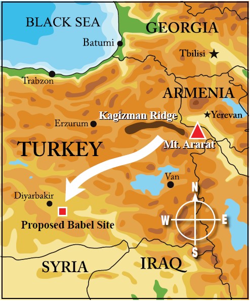
Figure 1. Map showing the locations of Kagizman Ridge, Mt. Ararat, and the proposed site for Babel. Note the travel direction (white arrow) from the “mountains of Ararat” to the Babel site, whether the Kagizman Ridge or Mt. Ararat itself, is from the east.
However, if the Tower of Babel was built in northern Mesopotamia and not southern Iraq, then the founders of Babel would have indeed traveled from the east if the Ark landed either on Kagizman Ridge or on Mt. Ararat (Figure 1). The Zagros Mountains location becomes completely unnecessary in this scenario.
Secondly, a Babel location in northern Mesopotamia affirms the high Cenozoic Flood/post-Flood boundary we have proposed.6,7 Examination of the geologic column in this part of southeast Turkey shows over 3,600 feet of Cenozoic marine limestones, shales, and sands atop a thick section of Cretaceous marine rocks.7 In fact, marine deposition continued across much of Europe, Turkey, and the Middle East through much of the Cenozoic.7 This equates to the Tejas Megasequence. In other words, the Flood did not end at the Cretaceous or K-Pg boundary (Cretaceous-Paleogene) because too much ocean sedimentation was still occurring across this region. The K-Pg was the high point of the Flood, occurring on Day 150. The rocks deposited after the Cretaceous, entailing much of the Cenozoic (Tejas Megasequence), was the receding phase of the Flood (Days 150 to 314).5
The exact location of the Tower of Babel and the landing site of the Ark still remain mysteries. Combining the biblical text with the geology and archaeology helps pin down the possibilities, further refining our interpretations. One thing we can be sure of is the book of Genesis is true.
References
- Griffith, K., and D. K. White. 2021. An Upper Mesopotamian location for Babel. Journal of Creation. 35 (2): 69-79.
- Clarey, T. 2019. The Ark Landed West of Mt. Ararat. Acts & Facts. 48 (7): 9.
- A paleo-ridge means the uplift existed well before the present. In this case, as the floodwaters were peaking.
- Zagros Mountains, Iran. The Geological Society of London.
- Clarey, T. 2020. Carved in Stone: Geological Evidence of the Worldwide Flood. Dallas, TX: Institute for Creation Research, 282-311.
- Clarey, T. 2020. Compelling evidence for an Upper Cenozoic Flood Boundary. Acts & Facts. 49 (5): 9.
- Clarey, T. L. and D. J. Werner. 2019. Compelling evidence for an Upper Cenozoic Flood/post-Flood boundary: Paleogene and Neogene marine strata that completely surround Turkey. Creation Research Society Quarterly. 56 (2): 68-75.
* Dr. Clarey is Research Scientist at the Institute for Creation Research and earned his Ph.D. in geology from Western Michigan University.


